Category: News

The White House takes on off-street parking

Few topics can spoil polite conversation as swiftly as politics, religion and off-street parking. In a gentrifying city such as Washington, new housing means new residents means more cars — and pointed questions from natives on where all of those cars will go.

Now, in a policy paper released Monday, the White House has taken a side, coming down against rules across the nation that require developers to build parking spots.

“Parking requirements generally impose an undue burden on housing development, particularly for transit-oriented or affordable housing,” the paper states. “When transit-oriented developments are intended to help reduce automobile dependence, parking requirements can undermine that goal by inducing new residents to drive, thereby counteracting city goals for increased use of public transit, walking and biking.”

The anti-parking stance came from a “Housing Development Toolkit,” a broadside against zoning. The report says zoning “reduced the ability of many housing markets to respond to growing demand,” making affordable housing hard to find in high-price areas.

Nixing off-street parking is not the paper’s only recommendation. It also advocates taxing vacant land, making it easier to get permits and making cities more dense.

NIMBYs have got to go, the paper states.

“Yes, in our backyard, we need to break down the rules that stand in the way of building new housing,” it says.

“We want new development to replace vacant lots and rundown zombie properties, we want our children to be able to afford their first home, we want hardworking families to be able to take the next job on their ladder of opportunity, and we want our community to be part of the solution in reducing income inequality,” it states.

The paper, which points out that Washington “saw a 31 percent increase in family homelessness last year amid a 14 percent increase in homelessness overall,” is not silent on the D.C. region. It praises Fairfax County’s flexible zoning for “encouraging economic development.”

“These more flexible zoning regulations include 40-50 foot increases in building height, parking requirement reductions, and abbreviated fees and approval processes for development changes,” it reads.

This was the policy paper many urban planners have been waiting for.

“This is an amazing document,” Jeff Speck, a city planner and the author of
“Walkable City: How Downtown Can Save America, One Step at a Time,” wrote in an email. “It gets just about everything right.”

Speck, a former D.C. resident, praised the paper’s endorsement of density and “accessory dwelling units,” also known as backyard cottages or “granny flats.”

Offering U Street, where he owns a property, as an example, Speck said new residents should not be able to get resident-only parking permits the city previously offered.

“Particularly in cities where alternatives to driving exist, on-site parking is a build-it-and-they-will-come phenomenon,” Speck wrote. “If a building has parking spaces, people show up with cars. If it doesn’t, people show up without them.”

Stewart Schwartz, executive director of the Coalition for Smarter Growth, a nonprofit that promotes walkable communities, said debates about density and parking were endemic to the region, often pitting longtime residents against new arrivals.

“It’s a battle in every neighborhood,” Schwartz said, citing the fight over Georgetown Day School development in Tenleytown and the “communities not canyons” debate over the height of planned buildings in downtown Bethesda.

Dennis Williams, a Tenleytown resident who spoke out last year against the Georgetown Day development, said that he was not familiar with the White House paper but that his community is “concerned about height and density.”

“Other kinds of housing and building high-rise buildings close to residential areas reduces the quality of the environment around which we live and in which people raise their families,” he said.

The White House paper is novel for pushing a philosophy the Obama administration is not known for: deregulation.

“Economic insights are finally creeping into the administration, and that’s a good thing,” said Sanford Ikeda, a professor of economics at the State University of New York whose work is cited in the paper.

The District’s Office of Planning, which has proposed doing away with parking requirements for new construction in the past, was not available for comment Tuesday.

Image credit: Amanda Voisard, The Washington Post

Click here to see the original story.

Guest Commentary: Walkable Urbanism in the City of Falls Church

People were streaming along the sidewalks and biking down the street – parents with children, couples, retirees, and the full ethnic diversity of our region. Where were they all going? We were leading one of our tours of walkable urban places and were amazed. Our group had just reached Park Avenue after having come up from the East Falls Church Metro. It felt like market day, and in fact it was – with the weekly Farmers Market, the Taste of Falls Church and the Fall Festival all taking place last Saturday.

Mayor Tarter, Vice Mayor Connelly, and Councilmember Hardi were there to meet us and tell us about the Little City. The Mayor talked about the community’s efforts to become an even better place for walking and bicycling, including adding Capital Bikeshare. We learned about the effort to bring new amenities like the Harris Teeter, and investment that will diversify the tax base to reduce pressure on residential property taxes. We learned about the city’s commitment to environmental sustainability and quality of life.

With the help of Falls Church’s planning department, our guides for the morning, we looked at old and new development along Washington and Broad Streets, talking about urban design, sidewalk widths, best designs for ground-floor retail and more. It was easy to feel the difference between walking along a narrow sidewalk next to high-speed traffic and the new wider sidewalks with street trees.

At the Northgate development, we talked about the benefits of redevelopment for dealing with long-standing stormwater problems. Old parking lots fuel torrents of floodwater into creeks like Four Mile Run. New development must meet current stormwater control standards and significantly reduce runoff. The sidewalk retention basins are one tool, although the big clunky ones at Northgate will have to be chalked up as a learning experience!

The Harris Teeter is the big new addition and lies within reach of most city residents, generating a significant number of walking trips to the store. Later, we learned from developer Bob Young about the sustainability features of his Flower Building and the affordable apartments for teachers in the Read Building. Parking needs are being reduced through shared parking at the Hilton Garden Inn. So many people arrive by shuttle from Metro, that they don’t need as much parking as they have.

The two Metro stations that bear the Falls Church name became a big topic of conversation, particularly because neither is as accessible as it could be. The long walk from East Falls Church Metro demonstrated, without a doubt, the need for a western entrance to the Metro at Washington Street. The western entrance would place the Metro much closer to many Falls Church and Arlington residents.

Metro studies show that attracting more riders who walk and bike to the stations is far more cost-effective than building very expensive parking structures. Almost all of Falls Church lies within one mile of one of the two Metro stations. So it’s easy to see why good sidewalks, bike lanes and bikeshare are great ways to connect the community to the two Metro stations.

East Falls Church Metro is already a champion in attracting bike commuters, but the demand is such that a bike station is in progress, designed by the same folks who created that amazing glass bike station at Union Station in DC. Bikeshare will add a whole new level of convenience for the commute to Metro, because you’ll be able to ditch the heavy bike lock. But the city almost didn’t win the funding in the face of opposition from outer suburban legislators and highway lobbyists. So we jumped into the fray, sending an alert to our Falls Church members, who responded in record numbers to send letters of support that helped to win the funding.

We didn’t have time to go to Tinner Hill or the West Falls Church Metro, but we learned about both and plan to come back. West Falls Church Metro is a disjointed place today and many talk about how the big parking lots feel unsafe at night. So it would be a real win to create a walkable urban place, with a new high school, mixed-use development, and a more vibrant Virginia Tech campus.

We wrapped up our tour in the pocket park at the Spectrum development, but people wanted to keep talking, so we adjourned for a great lunch at the Mad Fox.

Falls Church is a wonderful place, and in demand because of its walkability, convenient access to jobs and services, and nearby Metro stations. Carefully planned development in the commercial corridors will provide needed housing, convenient new services, help the tax base, and contribute to a walking and biking friendly community. We look forward to returning to see the next stages in the evolution of the Little City.”

Click here to read the original story.

Groups Taking Steps for Pedestrian Safety in White Flint

Advocates are trying to make walking safer in the area around the White Flint Metro Station in North Bethesda by posting safety tips in highly trafficked areas such as sidewalks and crosswalks.

Walking in the area, called the Pike District, is relatively new, said Amy Ginsburg, executive director of the Friends of White Flint. “Even as close as a year and a half ago, you’d rarely see people walking. Now you see people walking all the time,” Ginsburg said Wednesday. “Because of that change, we decided we needed an emphasis on pedestrian safety.”

Since 2010, planners envisioned that White Flint one day would be more walkable, where transit, residential units, services and jobs would be centralized.

Pete Tomao, Montgomery County Advocacy Manager for the Coalition for Smarter Growth, called it “suburban retrofitting.”Because of the transition, the Friends of White Flint wants to make the area as walkable as possible as quickly as possible, Ginsburg said.

“The easier we can make it for people to walk here, the more vibrant this area will become,” she said.

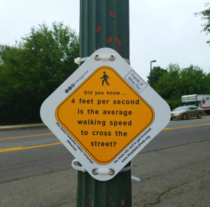
The dozens of signs on utility poles around Rockville Pike are the most visible part of the Pike District Pedestrian Safety Campaign, launched this week by Ginsburg’s group and the Coalition for Smarter Growth.

Tomao said the signs have 10 different slogans. One near a pedestrian signal takes a spin off Salt-N-Pepa: “You have to push the button, push it real good.”

One for wider streets says, “There’s no crosswalk here. We wish there was.”

The campaign aims to highlight pedestrian-friendly improvements, educate pedestrians on the safest way to navigate the neighborhood, and invite people to share their own suggestions for making the Pike District more pedestrian-friendly.

A community meeting is planned for at 6:30 p.m. Oct. 25 in the White Flint area around Metro (the location hasn’t been set yet) to discuss options. In the meantime, Ginsburg offered several possible solutions.

She said bushes need to be trimmed along sidewalks. And crosswalks need to be more visible.

“Cars aren’t expecting pedestrians,” Ginsburg said. “That’s not the habit everybody has in the White Flint area.”

There needs to be sufficient lighting for sidewalks as well as for streets, she said. Because the blocks through the Pike District are long, mid-block crossings are needed.

“This isn’t a car versus pedestrian issue. I think oftentimes it is seen as a win-lose argument. And it’s not. Everyone wins on this one,” she said.

To learn more about the campaign or to get involved, visit pikedistrictpeds.org.

Click here to read the original story.

RELEASE: Advocates Launch Campaign to Improve Pedestrian Safety in Pike District

FOR IMMEDIATE RELEASE

September 20, 2016

CONTACT
Pete Tomao, Montgomery County Advocacy Manager
Coalition for Smarter Growth
(516) 318-0605
pete@smartergrowth.net

Amy Ginsburg, Executive Director
Friends of White Flint
(301) 919-1609
amy.ginsburg@whiteflint.org

Advocates Launch Campaign to Improve Pedestrian Safety in Pike District

NORTH BETHESDA, MD – Dozens of signs with safety tips are going up on sidewalks, near crosswalks, and other highly-trafficked areas in the Pike District (which surrounds the White Flint Metro station in North Bethesda), in an effort by advocates to make walking safer and more attractive in the burgeoning area.

The signs are the most visible part of a broader effort, called the Pike District Pedestrian Safety Campaign, launched today by the Friends of White Flint and Coalition for Smarter Growth. The campaign highlights needed pedestrian-friendly infrastructure improvements, educates pedestrians on the safest way to navigate the existing environment, and invites people who walk in the area to share their own suggestions for making the Pike District more pedestrian-friendly.

whiteflintcampaign1  whiteflintcampaign2

“The Pike District is in the midst of an exciting transition. Guided by the 2010 White Flint Sector Plan, the area is becoming a vibrant, livable community where residents and visitors can walk to the farmer’s market, meet up with friends at happy hour, or catch a movie without having to drive to every destination. We’ve already seen a significant increase in pedestrian activity thanks to walkable projects like North Bethesda Market, North Bethesda Gateway, and Pike & Rose,” said Amy Ginsburg, the Executive Director of Friends of White Flint.

Ginsburg continued, “While walkability is improving, the road network in this area was really designed for cars more than for people. That can create a pretty inhospitable, even dangerous, environment for people on foot. Fortunately, there are a number of ways we can improve this situation in the near-term with simple and affordable solutions. Increasing crosswalk visibility, adding pedestrian refuges, and making walk signals automatic will be a huge help. That’s what this campaign is all about: practical solutions for a better pedestrian experience. We look forward to working with Montgomery County and the State of Maryland to make walking in the Pike District safer and easier.”

“We continue to see strong demand for walkable neighborhoods across the DC region, and the Pike District is no exception,” said Pete Tomao of the Coalition for Smarter Growth, which works for more walkable communities and transit investments region-wide. “Improving conditions for pedestrians will not only make thing safer for those who are already here, it will help the area attract new residents and businesses. Implementing these solutions now moves us closer to the Rockville Pike that county officials envisioned in 2010. It is our hope that we are able to push the Pike District to live up to its potential as a transit-oriented, walkable downtown,” said Tomao.

To learn more about the campaign or to get involved please visit pikedistrictpeds.org

###

New coalition wants a better ride for I-270 commuters

A political, civic and business coalition launched a campaign Monday to build support for what one leader described as “transformative” change along traffic-choked Interstate 270 in Maryland.

For their campaign kickoff, the group was savvy about picking a backdrop: They positioned themselves atop a slope in Germantown leading down to the highway. Through the wrap-up of their news conference about 9:15 a.m., the southbound traffic remained heavy and slow heading to the Capital Beltway, 16 miles away.

The coalition wants to revive dormant state studies that could lead to the addition of express toll lanes, which could manage traffic and also provide lane space and financial support for a regional rapid bus system. The regional buses would provide a limited stop service between Frederick and Rock Spring Park in the North Bethesda area, offering connections along the way to other transit and bus services. The coalition also supports construction of a local rapid bus system, known as the Corridor Cities Transitway, to link centers of activity between Shady Grove and Clarksburg.

Also part of this long-range plan for the corridor are a variety of other transit, cycling, pedestrian and road upgrades.

The costs of this long-range program would be in the billions of dollars. Supporters are looking to the express lane tolling as a key source of revenue. Several advocates pointed to Virginia’s network of high-occupancy toll lanes, partly financed by enlisting private partners to build the HOT lanes in exchange for the right to collect the toll revenue.

“It’s time for us to think of this situation in a transformative manner,” said Rep. John Delaney (D-Md.), the honorary chairman of Fix270NOW. Incremental fixes won’t work for such a big people-moving problem, he said. “We’ve been thinking small-ball for too long.”

Richard Parsons, vice chairman of the Suburban Maryland Transportation Alliance, a business and civic advocacy group with parallel interests, said the new coalition welcomes the plan presented by Gov. Larry Hogan (R) to award $100 million for innovative congestion management programs on I-270. The coalition’s theme is that I-270, the main stem of the suburban technology corridor as well as the key route for thousands of commuters headed to and from the region’s core, needs much more help than that.

In Maryland’s transportation planning system, local government support for projects is a prominent element in state financing decisions. So the Fix270NOW group wants to get a clear statement from the Montgomery and Frederick County governments that the improvement of I-270 is a top transportation priority. Once that status is clear, the group wants the Maryland Department of Transportation to revive work on two studies, now many years old, that looked into travel solutions for I-270 and the west side of the Capital Beltway in Maryland.

“It’s time to finish those studies,” said Rep. Chris Van Hollen (D-Md.), who also spoke in support of the new group.

The Commonwealth Transportation Board, Virginia’s top policymaking panel on transportation, has expressed interest in engaging Maryland in a discussion of cross-Potomac transportation improvements. Some advocates for congestion relief say it would be logical to extend Virginia’s Capital Beltway HOT lanes from the Tysons area across the Legion Bridge and north to I-270.

But the Hogan administration has been cool to this idea. During an online discussion with Dr. Gridlock readers in July, state Transportation Secretary Pete K. Rahn noted that “in Virginia and Maryland, these express toll lanes require substantial upfront state investment into the projects that will typically not be recovered.”

“Congestion-busting solutions” — a term Rahn applied to multi-billion-dollar programs that take many years to complete — can’t be supported by the financial resources available in Maryland, he said.

Maryland has built several express tolling systems in recent years. The Intercounty Connector in Montgomery and Prince George’s features all-electronic tolling at rates that vary with the time of day. Last year, the state opened the I-95 Express Toll Lanes in the middle of I-95 north of Baltimore, using a tolling system similar to that on the ICC.

But Maryland has nothing quite like the Virginia HOT lanes, which vary the tolls based on the level of traffic to maintain steady speeds and offer a free ride to carpoolers using a specialized type of E-ZPass called the Flex.

Parsons said that once the state studies were revived, transportation planners could review what type of express lanes might work best on I-270.

Stewart Schwartz, executive director of the Coalition for Smarter Growth, was skeptical of the express lanes approach for I-270. “Widened highways in metropolitan areas can fill up again in as little as five years,” he said in a statement Monday.

Instead, Schwartz recommended extending the I-270 HOV lane to the Legion Bridge, expanding MARC commuter train service from Frederick, enhancing commuter bus service in the I-270 corridor and encouraging development around transit centers.

Image courtesy of Robert Thomson.

Click here to view the original article.

An early report card on D.C. Mayor Muriel Bowser’s affordable housing efforts

Lowering housing costs requires more than writing a check, and come the 2018 election Mayor Muriel E. Bowser may be judged more on her ability to simultaneously work with — and regulate — housing developers than on her $100 million annual commitment.

After all, Bowser isn’t the first D.C. mayor to propose a major increase in housing spending; her predecessor, Vincent C. Gray, also proposed putting $100 million annually into the city’s Housing Production Trust Fund.

Plus, because developers also play a central role in funding city political campaigns, Bowser’s toeing of the line between advocating for poor residents and facilitating new projects often comes under close scrutiny.

What decisions have shaped Bowser’s housing record so far? Here are three.

Get the money out faster: Trust fund dollars typically fill financing gaps for projects relying on a bevy of other public and private sources. For the District to effectively spend $100 million a year, the private market must submit timely, appropriate projects.

Under Gray, there was not a large enough pool of developers to consistently bring quality projects.

“We were seeing the same names as the sponsors of some of these [funding] requests,” said Jeff Miller, deputy mayor for planning and economic development under Gray. “Doing these projects means a lot of brain damage, and a lot of people aren’t necessarily specialists in it.”

Building private-sector interest requires demonstrating there will be ongoing opportunities to build affordable units if companies commit to it. Polly Donaldson, Bowser’s housing director, is issuing more requests for projects and assessing them more quickly. Previous funding requests went out every year or two; Donaldson is shooting for every six months.

“Knowing that there is certainty in the amount of money that the city is putting into affordable housing production actually motivates all the other stakeholders,” said Claire Zippel of the D.C. Fiscal Policy Institute, an advocacy group. “Look at philanthropy, look at the banks – there are other sources going in the door, and it gives the other sources confidence that the city is there and it’s going to step up on a consistent basis.

Rushing to get money out the door has obvious pitfalls however. Bowser’s plan to build seven new homeless shelters across the city was so beset by unnecessary costs that it was modified before being passed by the D.C. Council.

Fix inclusionary zoning: As of last spring, many onlookers agreed that the District’s inclusionary zoning program — which requires developers of most housing projects to include some affordable units – had been a colossal failure. In six years, it had generated an average of one for-sale unit and eight rental units annually.

When advocates pressed for changes, Bowser’s administration floated multiple proposals, one of which would have required builders to offer units at much more deeply discounted rents than the current law requires.

A number of advocates backed one of the administration’s proposals – only to see it pulled back after criticism from developers who said it would be too expensive.

The advocates won the day, and they are encouraged at how the District overhauled the system for delivering inclusionary zoning units to people on a waiting list.

The DC Department of Housing and Community Development “has gotten better and better at administering inclusionary zoning and deserves a lot of credit for improving the administration of the program,” said Cheryl Cort of the Coalition for Smarter Growth. “A lot of the early problems are gone, and the administration is working very hard to figure out the process. They’ve cut by substantial amounts the time it takes to place an applicant into a unit.”

Hold developers to their commitments: As a member of the D.C. Council, Bowser helped weaken a bill requiring deals for District-owned land to include affordable housing.

However, as mayor she applied the new rules before they went into effect, picking up three development deals she inherited in rapidly gentrifying areas and requiring the developers to include affordable units in their projects. That will create 162 new units.

If the economy tightens, Bowser is likely to face more of these decisions. The District previously rolled back affordability requirements on the Southwest Waterfront project, for instance, as that project’s developers were in search of financing during the last downturn.

So far she has held strong on affordability. When developer Don Peebles came to the administration looking for relief from a requirement that he build 61 affordable units as part of a deal to build high-end hotels and condos on D.C. land in Mount Vernon Square, he received a direct answer: No deal without all 61 units.

Image courtesy of Katherine Frey.

Click here to read the original article.

RELEASE: Smart growth advocates push back against campaign for HOT lanes on Maryland’s I-270 with alternatives that acknowledge induced travel exists

FOR IMMEDIATE RELEASE
September 19, 2016

CONTACT
Pete Tomao, Montgomery County Advocacy Manager
(516) 318-0605
pete@smartergrowth.net

Stewart Schwartz, Executive Director
(703) 599-6437
stewart@smartergrowth.net

Smart growth advocates push back against campaign for HOT lanes on Maryland’s I-270 with alternatives that acknowledge induced travel exists

MARYLAND – Today, as part of a mounting campaign for high-occupancy toll (HOT) lanes on Maryland’s I-270, the Suburban Maryland Transportation Alliance (SMTA) proposed significant expansion along the entire highway from the American Legion Bridge on I-495, north into Frederick County.

In response, advocates at the Coalition for Smarter Growth voiced concern over the approach laid out by SMTA’s Richard Parsons and released a package of more effective alternatives for the I-270 corridor.

“Mr. Parsons has effectively claimed that induced travel – the basic economic principle that building more roads causes more traffic – doesn’t exist, and that’s simply wrong,” said Stewart Schwartz, Executive Director of the Coalition for Smarter Growth. “Widened highways in metropolitan areas can fill up again in as little as five years.”

“We are releasing a package of approaches for the I-270 corridor in response to Mr. Parsons’ aggressive expansion campaign,” continued Schwartz. “Over two years ago, we were the group that recommended the first-ever summit of the Montgomery County Council and Fairfax County Board of Supervisors, with the express purpose of addressing problems at the American Legion Bridge. So we’ve long been focused on smart fixes for this major commuting corridor.”

The Coalition for Smarter Growth recommended the following alternatives to end-to-end widening:

  1.  Near-term extension of the I-270 bus and HOV lane to and across the American Legion Bridge to provide an important option to driving alone and move more people, more quickly through the corridor.
  2. Expansion of MARC service from Frederick in accordance with the MARC investment plan, taking Frederick County residents to jobs in Montgomery and DC.
  3. Expanded commuter bus service on I-270 from Frederick County, and bus rapid transit along Route 355 from Bethesda to Clarksburg. Expanded express bus service from Clarksburg to Shady Grove Metro.
  4. Transit-oriented development along the Red Line in Montgomery County to handle population growth without increasing regional traffic, and enhancing the county’s competitiveness.
  5. A smart growth comprehensive plan for Frederick County, to create walkable development with good access to transit, while conserving farms and forests and reducing the amount residents have to drive.
  6. Continued protection of Montgomery County’s Agricultural Reserve and major drinking water supplies.
  7. Longer-term connection of Metrorail or light rail between the Silver and Red Lines, after Metro’s rehabilitation is complete and the system is adequately funded.

“Induced travel is a very real problem. It can mean billions of wasted tax and toll dollars spent on road expansions that don’t provide long-term solutions,” said Schwartz. “That’s the path Parson’s wants to lead us on. So, while we can focus on fixing key road bottlenecks, we need to apply the rest of our resources to providing transit options and ensuring more efficient patterns of land development. Linking walkable communities with transit is the only long-term effective way to improve access to jobs and daily needs and maintain our economic competitiveness.”

In 1999, the Washington Post published a groundbreaking article documenting the induced travel effect of a previous expansion of I-270 from 8 lanes to 12 lanes. A huge volume of academic research has documented induced travel. Much of it has been compiled and summarized by Todd Litman of the Victoria Transportation Policy Institute in his paper Generated Traffic and Induced Travel, Implications for Transport Planning, 12 September 2016.

“We understand that Mr. Parsons may be talking about a public-private partnership (P3) for HOT lanes, like those in Virginia, but we don’t like to see the P3 tail wag the transportation dog. Before jumping to the conclusion that HOT lanes, and private ones at that, are the way to go for I-270, we need to look at the effects on land use and long-distance commuting, the fact that transit routinely gets the short end of the stick in these deals, and evaluate the more effective long-term approach of smart growth with transit,” said Schwartz. “P3 deals concern us because they divert significant resources — usually in large federal loans — away from transit investments, and often give all profits to the private contractor for 75 years.”

“In short, we support a package of short-term transit and HOV investments like those at the American Legion Bridge, long-lasting transit investments like Marc, Metrorail, and BRT combined with more efficient land use, and a very deliberative approach to studying the issues with full recognition of the problem of induced travel,” concluded Schwartz.

About the Coalition for Smarter Growth
The Coalition for Smarter Growth is the leading organization in the Washington DC region dedicated to making the case for smart growth. Its mission is to promote walkable, inclusive, and transit-oriented communities, and the land use and transportation policies and investments needed to make those communities flourish. Learn more at smartergrowth.net.

###

McMillan isn’t next to Metro, which is less of a problem than you think

Yes, the McMillan Sand Filtration Site is one mile (from either end of the site) to the Red Line. It’s even 0.6 miles to the nearest express bus route (Georgia Avenue’s 79), and key network improvements are still in the planning stages. Yet from the point of view of someone who wants to reduce auto dependence (and the concomitant pollution, injury, and sprawl), what matters most is that MSFS is close to downtown, rather than close to Metro.

Transportation planning research has consistently shown that location relative to downtown and to other land uses is far more closely associated with the amount of driving than location relative to transit. Ewing and Cervero’s definitive 2010 meta-analysis (cited by 679 other scholarly articles) examined over 200 other studies, then combined the correlations found by 62 different studies:

Yes, it turns out that the number of miles that people drive is four-and-a-half times as closely correlated with the distance to downtown than with the distance to a transit stop. This strong relationship between driving and distance to downtown is borne out in local survey research by MWCOG/TPB. Note that whether an area has Metro access (like Largo or White Flint, vs. the Purple Line corridor) doesn’t actually seem to impact the number of drive-alone (SOV) trips.

Some suggest that development proposed for this site should instead go elsewhere. If the development is denied, those residents and employees and shoppers won’t just disappear, they’ll just go somewhere else. They won’t go to superior locations even closer to downtown and Metro (because those are so very plentiful!), but rather to far inferior locations. For instance, the life-sciences employers might choose an alternative location within our region that has already approved a similar mix of uses — such as Viva White Oak, Inova Fairfax, Great Seneca Science Corridor, and University Center in Ashburn, all of which are much further from both downtown and Metro.

This isn’t just the suburbs’ fault. Within the District, even more intensive development than what’s proposed at MSFS has already been given the go-ahead at locations such as the Armed Forces Retirement Home, Hecht Warehouse, and Buzzard Point. All of those sites are also inferior to MSFS from the standpoint of not just transit accessibility and distance to Metro Center, but also on all of the other factors shown to reduce VMT.

If the “Reasonable Development” types truly do care about reducing driving, I must have missed their years of caterwauling over the approval of all these other sites — not to mention the countless suburban developments that together pave over 100 acres of open space every single day in the Chesapeake Bay watershed. That’s why I give more credence to the people who do actually care about paving over the region, like the Piedmont Environmental Council — a/k/a the Coalition for Smarter Growth.

Click here to read the original article


Trying to navigate Metro during SafeTrack? Here are some apps that can help.

With SafeTrack in full swing, those sometimes painful Metro commutes may seem even more so.

Single-tracking, station closures and partial line shutdowns have made Metro planning essential. And to do so, many riders have turned to an array of apps. We asked members of  “Off the Rails,” our private Facebook group where Metro riders discuss the system’s impact on their daily lives, which apps they’re using.

Our informal survey gave way to a fruitful discussion. Bear in mind, some people had multiple favorites. And don’t forget that there are always official channels like Metro’s Trip Planner and BusETA to help you map out your commute.

Here’s what they recommended:

MetroHero

This was by far the favorite. In addition to providing the usual dashboard of wait times and a line-by-line breakdown of Metro service disruptions, this app displays Metro’s train locations in real-time, providing a way to visualize congestion in and out of the tunnels.

One Off the Rails member said it’s essential for planning trips on the Silver Line, which he says is “not super regular sometimes.”

“It lets me time when I leave my house so I don’t have to wait, even on normal days,” he said.

Transit App

This app culls all the available transit data in the region and displays it in a clean, simple dashboard. Where’s the nearest bus stop? How far is the Metro? And what if I want to use Capital Bikeshare? It’s all available on one screen in Transit App, which claims to work in 125 metropolitan areas with open transit data.

find a metro

The Coalition for Smarter Growth’s Aimee Custis put it like this: “I’ve used it forever, and…it isn’t broken.”

The app provides wait times and delay information, in addition to map showing landmarks along the way.

Custis: “I chose it originally because it would show me not only Metro trains, but Metrobuses, AND Circulator buses. It also has an offline system map and trip time calculator function, and saves my most commonly-used Metro stations (and others I use) as favorites, which saves me time.”

Metro Now

Off the Rails member Kevin Combes is partial to this app, which he developed himself.

He says it’s a no-frills companion that lets riders instantly access their train times.

Combes: “If you let it access your location, it will auto-select the nearest station when you load the app. Ideally, you open the app and your train times are just there. It also gives you a visual alert if there are official WMATA delays.”

MetroMinder DC

This app, famous for its “heat maps” showing on-time performance and line-by-line delays, is popular with D.C. commuters. It ranks stations in real time on a spectrum from “Great” to “Argh!” As in “The Red Line is SafeTracking this week…’Argh!’”

Moovit

Used by an estimated 45 million people worldwide, Moovit claims to be the no. 1 global app for public transportation. It’s got live walking directions and data for 1,200 cities in 66 countries. And its interface is pretty.

Compatibility: iPhone, Android

D.C. Metro and Bus

The region’s most popular app for local transit, D.C. Metro and bus features train and bus wait times in a simple interface. It’s handy if you need a copy of a Metro map, and also displays Circulator wait times for those needing to navigate the District.

iTrans DC Metro

This app has real-time arrivals, schedule information, directions, push alerts and line diagrams. Off the Rails member Michael Pratt says he uses it for delay-related push alerts.

Compatibility: iPhone

Twitter

Another revelation to come from our unscientific poll: Metro riders have a Twitter habit.

Off the Rails member Tom Spinčić said he relies mostly on Twitter to monitor Metro alerts. Michael Zwirn, another member of the group, agreed.

“True: Twitter alerts tell me about looming issues faster than anything more official!”

Click here to read the original article


RELEASE: Reaction to NOVAChamber Summit — TOD is the key!

Coalition for Smarter Growth, Piedmont Environmental Council, Sierra Club – Virginia Chapter

For Immediate Release:
August 31, 2016

Contact:
Stewart Schwartz, CSG, 703-599-6437 (cell)
Chris Miller, PEC, 540-347-2334
Douglas Stewart, SC, 703-407-2790 (cell)

Statement Regarding NOVAChamber Summit: Competitive Future for Northern Virginia and DC Region is Transit-Oriented Development

Tysons Corner: Today, the chambers of commerce of Northern Virginia held a business summit with the leading elected officials of Northern Virginia’s five largest jurisdictions to discuss a variety of issues including Metro funding, economic competitiveness, workforce development, and an upper Potomac Bridge crossing. While the chambers have been big boosters of an upriver bridge, smart growth and conservation groups have long made the case that transit and transit-oriented development (TOD) are the most effective and competitive way to grow.

“We were encouraged that the elected leaders on the panel at today’s summit emphasized the importance of Metro and TOD, along with workforce development, and didn’t indicate that an upriver bridge is a priority,” said Stewart Schwartz, Executive Director of the Coalition for Smarter Growth. “Recent experience demonstrates that the most effective way for Northern Virginia and the region to grow and maximize economic competitiveness is through transit and transit-oriented development (TOD), not by diverting billions of dollars to an outer beltway with upper Potomac bridge. Profound and lasting market shifts have demonstrated the demand for TOD and its benefits. Our transportation investments must be focused on supporting Metro, new transit, and TOD.”

Companies are leaving office parks in favor of urban centers with transit. The CEO of Marriott has said his company will move from their office park to a Metro station. Over 84% of new office development in the pipeline has been within ¼ mile walk of Metro. Millenials and downsizing empty nesters are flocking to walkable urban places with DC gaining about 100,000 people in the past 12 years.

“Recent business summits in Loudoun have trumpeted the need for mixed-use, walkable, transit-oriented development. Loudoun’s competitiveness, like that of Fairfax and the inner suburbs, depends on creating the places the next generation workforce wants to be. That includes not only walkable urban places with transit but also parks and outdoor recreation including nearby rural areas. This should be Loudoun’s focus,” said Chris Miller, President of the Piedmont Environmental Council.

“An upper Potomac bridge would harm the Montgomery Agricultural Reserve, Seneca Creek, and Potomac River. It would fuel more auto-dependent development, more driving, more air pollution and higher greenhouse gas emissions,” said Kelsey Crane, Northern Virginia Organizer for the Sierra Club – Virginia Chapter. “Past studies have shown that the overwhelming travel demand is in the American Legion Bridge corridor, which needs transit connections between the Silver Line and Red Line and associated job centers. Chairman Bulova emphasized today the importance of addressing this corridor.”

“TOD generates far more tax revenue per acre and will fuel the economic engine of Northern Virginia. In contrast, an outer beltway with upper Potomac bridge will fuel further decentralization, traffic and inefficiencies in infrastructure. So we urge the chambers to support a sustainable, competitive transit-oriented future, not a 1950’s approach to transportation, and we welcome the opportunity to campaign with them for the transit funding we need,” said Schwartz.

Finally, the groups expressed disappointment that the event did not include discussion of the importance of providing more housing close to jobs and transit for all levels of the workforce. “We are facing an affordability crisis, and need more multifamily and attached housing in walkable neighborhoods close to jobs and transit. Fairfax’s push for mixed-use redevelopment in its older commercial corridors is an example of what must be done, but the region needs to speed the process of providing more homes close to jobs and transit,” concluded Schwartz.

About the Coalition for Smarter Growth
The Coalition for Smarter Growth is the leading organization in the Washington DC region dedicated to making the case for smart growth. Its mission is to promote walkable, inclusive, and transit-oriented communities, and the land use and transportation policies and investments needed to make those communities flourish. Learn more at smartergrowth.net.

About the Piedmont Environmental Council
The Piedmont Environmental Council (PEC) was founded in 1972 to promote and protect the Virginia Piedmont’s rural economy, natural resources, history and beauty. Headquartered in Warrenton, VA, we have offices throughout a nine county Piedmont region that includes Albemarle, Clarke, Culpeper, Fauquier, Greene, Loudoun, Madison, Orange and Rappahannock counties. Learn more at pecva.org.

About the Sierra Club – Virginia Chapter
The Virginia Chapter of the Sierra Club is 15,000 members strong. We are your friends and neighbors working to build healthy, livable communities, and to conserve and restore our natural environment. Every day, dozens of volunteers are taking action with the Sierra Club in Virginia. Learn more at sierraclub.com/Virginia/about.

###