The Commonwealth Transportation Board, Virginia’s decision-making panel on roads, rails and other mobility efforts, is ready to spend money. Now that the governor and General Assembly have given the board more revenue to work with, a lull that set in over the past few years may yield to a more active phase of transportation projects.
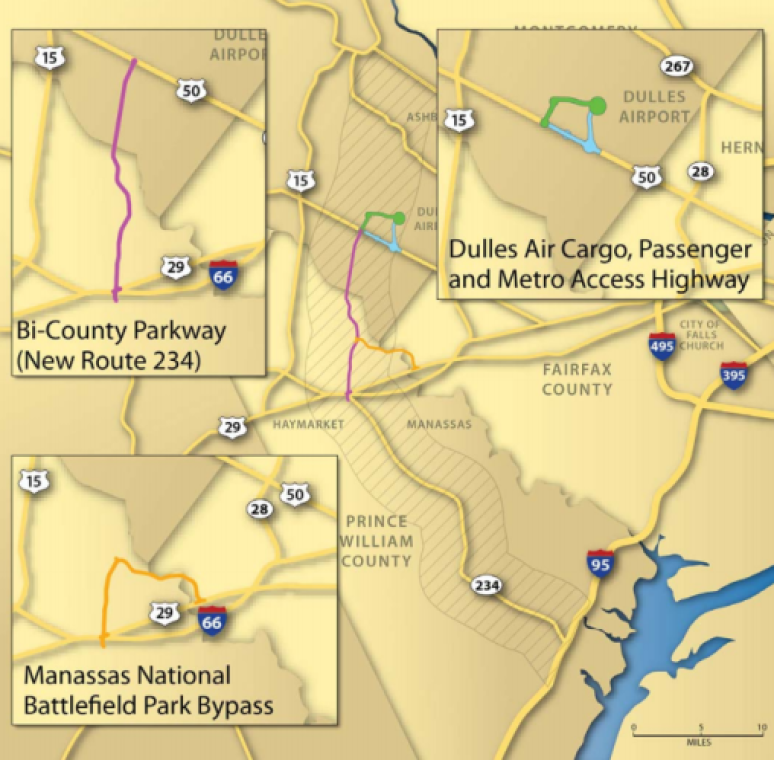
Many Northern Virginians are aware of this changing dynamic, so they came to a public meeting sponsored by the board Tuesday night in Fairfax County to argue for or against particular projects. The most frequently mentioned were the rebuilding of the interchange at Interstate 66 and Route 28 — everybody’s for that one — and the proposed Bi-County Parkway, which has generated strong opposition in the neighborhood bordering the north-south corridor on the western edge of the Manassas National Battlefield Park.
The broader issues at play emerged when two people spoke: Stewart Schwartz of the Coalition for Smarter Growth and Bob Chase of the Northern Virginia Transportation Alliance.
Schwartz urged the transportation officials to pursue a “fix it first” strategy in setting priorities. Rather than focusing new spending on expansion of the roads network, rebuild the deteriorating parts of the existing system to make it easier for people to get around.
Schwartz doesn’t equate road building with congestion relief, which puts him at odds with many of the people who supported Virginia’s new transportation revenue law. New lanes, he said, “can generate more traffic than you relieve.”
Land use policy that focus development near transit “is a regional traffic solution” and does a lot more to address congestion than new lanes, Schwartz said. This may be the way of the future as empty-nesters who no longer need their big houses but want to stay in Northern Virginia seek new housing positioned to let them stay mobile as they age.
Schwartz opposes the Bi-County Parkway as, among many other things, a traffic-inducer. But it’s an unfair shorthand to characterize him as anti-road. Of the plan to rebuild the I-66/Route 28 interchange, he said, “We agree it should be fully funded.” But planners deciding how to ease the awful congestion all along the I-66 corridor need to address the public’s desire for better transit service, Schwartz added.
He also noted that Virginia state officials who are contemplating the new transportation revenue need to get interested in Metro’s long range plan, called “Momentum,” to expand the transit system’s capacity, including the purchase of enough rail cars to make all trains eight-cars long.
The shorthand for Chase would have him be the road-building guy, but that’s also unfair. Chase backs construction of Metro’s Silver Line. Key elements in his vision are that transportation projects can solve congestion problems, but we need to think big, and the projects selected need to have regional impact.
Chase praised state leaders for approving new transportation revenue that can refill budgets for maintenance and construction. “After many years, we finally are talking about additions, rather than subtractions,” he said.
In this new environment, Chase said, a “big picture perspective is more important than ever.” Planners must target “regionally significant transportation investments that will reduce congestion,” and he looks to the Commonwealth Transportation Board and the Virginia Department of Transportation to provide the leadership that will support such projects, including the Bi-County Parkway. People who say they don’t want a parkway in their yard have a right to oppose it, he said, but to say that the region doesn’t need a north-south route in that area isn’t factual. The state must base it’s decisions on regional needs, Chase said.
Chase and Schwartz have been fighting it out along this line for years. The key difference in 2013 is that they’re now talking to officials who have money to spend.
Photo courtesy of Karen Bleier. Click here to read the original story.