Montgomery County’s push for transportation investment paid a billion-dollar dividend Monday when the state committed money to eight county road, rail and bus priorities.
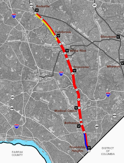
The lion’s share of funding, $680 million, will go to the Purple Line, a 16-mile light rail line planned to connect Bethesda and New Carrollton. Other projects, like the Corridor Cities Transitway, Ride On Bus system and road improvements, will see smaller cash commitments from the state.
Standing above the Bethesda Metro Station Monday, Gov. Martin O’Malley announced the investments, saying that they will bring needed jobs and traffic relief.
Led by County Executive Isiah Leggett (D), Montgomery pushed for an increase in the statewide gasoline tax in the 2013 legislative session. It sought a cash commitment from the state to the $2.2 billion Purple Line as well as the Corridors Cities Transitway — a 15-mile bus rapid transit line that will connect Clarksburg to the Shady Grove Metro Station, estimated to cost $545 million.
Over the “last few decades,” Maryland stopped making necessary investments to build and maintain its transportation infrastructure, O’Malley (D) said Monday.
“The failure to act, the failure to make those better decisions, had a huge cost,” he said.
Time, jobs and the environment were sacrificed, he said.
Maryland lawmakers passed the Transportation Infrastructure Investment Act this spring to bring $4.4 billion in new investment and 57,000 jobs in the next six years.
Flanked by dozens of state lawmakers, local leaders and members of the building trade, O’Malley said Montgomery’s cut of that money will include:
— $400 million for construction of the Purple Line, which comes on top of $280 million announced previously to buy land and finish the project’s design
— $125 million to construct a new interchange along I-270 at Watkins Mill Road
— $100 million to buy land and design the Corridor Cities Transitway
— $85 million for Montgomery’s Ride On Bus system
— $25 million to build relocate a section of Md. 97 (Georgia Avenue) to bypass the Town of Brookeville
— $7 million to build interchanges at U.S. 29 and Musgrove Road and at U.S. 29 and Fairland Road
— $3 million to design the widening of Md. 124 (Woodfield Road) from Midcounty Highway to south of Airpark Road
— $3 million for planning to evaluate possible improvements in the Md. 28/Md. 198 corridor between Md. 97 and I-95.
Lt. Gov. Anthony Brown, who shepherded a bill through the General Assembly this year that became the state’s new public-private partnership law, said the state will deliver the Purple Line as the state first and largest transit partnership with private industry. The state will seek a private company to build and operate the line.
“It’s a project that is going to connect our communities and grow our economy,” Brown (D) said. “With the additional $400 million the governor just announced, we are showing how serious we are to delivering the Purple line now.”
Montgomery looks to add 100,000 jobs through its efforts in the Great Seneca Science Corridor, Shady Grove, White Flint, and White Oak, Leggett said.
“However, all of that depends on improvement in our transportation infrastructure,” Leggett (D) said. “Without that [investment] those jobs may come to a screeching halt.”
Montgomery leaders warned last December that without dedicated funding and clear state commitment to the project, the almost completely designed Purple Line would stall in its tracks.
“All of this is about better choices,” O’Malley said.
But not everyone gathered on the Metro plaza supported the projects, namely the Purple Line.
Shouting “Bury the rail, save the trail,” opponents of the Purple Line frequently voiced their position over those who spoke.
Deborah Vollmer of Chevy Chase said the rail line will lead to incalculable loss along the Capital Crescent Trail, a hiker-biker trail that, at points, parallels the Purple Line’s planned path. Not opposed to mass transit, she said the rail should be buried to avoid impacting the park-like atmosphere of the trail.
Ajay Bhatt, president of Friends of the Capital Crescent Trail, said the announcement was bad news for the county’s green spaces.
“They talked a lot about development and a lot about growth in Maryland, but where are the parks going to come into play?” he said.
His organization is concerned that the Purple Line will take away the trail’s ambiance by placing parts of it next to the planned light rail.
After the announcement in Bethesda, Bhatt argued the Capital Crescent Trail is a valuable resource for downcounty residents.
“If you go on the Capital Crescent Trail between here and Georgia Avenue, it’s packed,” he said.
For transit advocates, the state commitment for the Purple Line was tempered by concerns over continued investment in highway projects.
Cheryl Cort, policy director of the Coalition for Smarter Growth, said investing in highway expansion projects only gives drivers temporary traffic relief and encourages more driving. It does not give resident the transportation choices they deserves, Cort said.