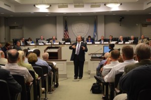
 Members of the public from Loudoun, Arlington, Fairfax and Prince William counties got their first chance to speak to the full board of the Northern Virginia Transportation Authority Thursday night in a public hearing discussing the projects that could receive funding from the General Assembly’s transportation bill that passed earlier this year.
Twenty-two people, including legislators, representatives of local advocacy groups and individuals giving their opinions, went before the board, and dozens more reviewed the almost 50 projects the NVTA is considering. The NVTA’s priority is finalizing a list of projects that will receive funding for FY14, when there is expected to be $190 million available.
NVTA Chairman Martin Nohe, the Coles District Supervisor in Prince William County, gave a 30-minute presentation before anyone spoke, explaining what the NVTA is and how board members plan to implement the funding. $1.6 billion is expect to come to Northern Virginia over the next six years from HB2313, 70 percent of which will be dispersed by the NVTA and 30 percent going directly to each locality: the four counties and the cities of Manassas, Manassas Park, Falls Church and Alexandria.
The money is intended, essentially, to relieve the high levels of congestion that have plagued the area for years, and only figure to get worse. The main bone of contention among those who spoke was the best way to go about doing that.
“There’s a lack of quantitative information right now to evaluate projects with different modes and different types,” Del. Jim LeMunyon (R-67) who was the first to speak, said. “For every million dollars we spend, how many hours are we putting back into the lives of Northern Virginians? We need to know that.”
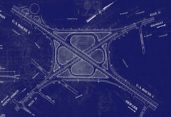
Residents in Prince William and Loudoun counties almost unanimously applauded the NVTA’s to fund the widening of several segments of Rt. 28 in Loudoun, Fairfax and Prince William counties.
The projects proposed for FY14 funding are “hot spot” improvements between Sterling Boulevard and the Dulles Toll Road in Loudoun, expanding from two lanes to a four-lane divided roadway from Linton Hall to Fitzwater Drive in Prince William, and widening from three to four lanes southbound between the Dulles Toll Road and Rt. 50 and northbound from McLearen Road to the Dulles Toll Road in Fairfax County.
“I’m here to commend your decision to include the Rt. 28 hot spot improvements,” Jeff Fairfield, speaking on behalf of the Rt. 28 Tax District Landowners Advisory Board, said. “These improvements will alleviate congestion. There’s been a tremendous improvement on removing traffic lights, yet we now experience congestion due to a lack of lane capacity.”
“Rt. 28 relief is needed now,” Gary O’Brien of Manassas said. “There are currently several disconnected projects. What it needs is more transportation capacity, right through the system. Try to consolidate the little plans into a larger system.”
Arlington County Supervisor Chris Zimmerman, the chairman of the Project Implementation working group, said the list of projects proposed for funding was built from existing transportation plans, such as the NVTA’s TransAction 2040, and are closest to “shovel-ready.”
“Our aim has been to, No. 1, follow the law” Zimmerman said. “We began by reviewing what the statutes require of us. In developing criteria, that was first and foremost. It has been our intention to use objective criteria and quantifiable criteria to the greatest degree possible. That is what we have been trying to accomplish.
“Many of the projects, by their nature, will take multiple years to do and have multiple parts. It’s a very complex network; there isn’t a silver bullet. It will take a lot of fixing in different places.”
Many Prince William County residents spoke against potential funding of the Bi-County Parkway, a controversial transportation project stretching from I-95 to Rt. 50 in Loudoun, but the project is not among those included for FY14 funding or on the Six-Year Plan.
Perhaps the most scrutinized debate will be how many funds are devoted to transit projects, pedestrian or bicycle projects, and how much will simply be devoted to increasing capacity on the roads network.
“In a great metropolitan area, you cannot ‘get the red out,’” Stewart Schwartz, the executive director of the Coalition for Smarter Growth, said about relieving intense traffic jams. “We have to account for induced traffic. For the peak-hour commute, there’s nothing better than high-capacity transit. I urge you to resist a return to the old approach, which didn’t work, and focused on a transit-oriented, walkable bikeable future that we need to have.”
The NVTA will hold another public hearing July 24 before deciding upon the final FY14 list at 6 p.m. Wednesday, July 24, at Fairfax City Hall. The public comment period before the Project Implementation’s next working group will close next week. The form, and submittal information, can be found here.
Photo courtesy of Leesburg Today.
Click here to read the original story>>