We applaud the Go Prince George’s plan for fully applying the 2023 DPW&T Urban Street Design Standards mandated by the County Council. But the plan could be even better.
Category: Prince George’s County
Central Avenue-Blue/Silver Line Sector Plan factsheet
The Preliminary Central Avenue-Blue/Silver Line Sector Plan outlines a long-term vision to guide the development of Inner-Beltway communities along Central Avenue, through the year 2045.

MD 214 Pedestrian Safety Action Plan factsheet
Six lanes is too wide & risky for MD 214. The proposed concepts to address pedestrian safety on this segment of MD 214 are greatly disappointing and fall far short of meeting project goals.
Testimony: MD 214 PSAP project plans fail to address pedestrian safety (MD)
The proposed concepts to address pedestrian safety on this segment of MD 214 are greatly disappointing and fall far short of where we believed we were headed with this project.
Testimony: CSG Support for Silver Hill Apartments (MD)
This worthy project could bring 250 affordable apartment homes to a vacant site that is only a quarter-mile walk to the Suitland Metro Station.
Event materials: Maryland Housing Needs & Solutions: Why is housing unaffordable, and what can we do to fix it?
At this webinar on December 8, 2025, we discussed two recent reports offering insight into why housing is so unaffordable, what its impact is, and what to do about it with a Maryland all star cast ⭐️:
- Kathryn Howell, PhD, Director of the National Center for Smart Growth, University of Maryland College Park & Associate Professor, Urban Studies & Planning Program
- Dani DiPietro, Policy Research Director, Office of the Comptroller of Maryland
- Natali Fani-González, Council President and District 6 Councilmember, Montgomery County, Maryland
- Moderated by Scott Gottbreht, PhD, Assistant Secretary for Policy, Strategy, & Research, Maryland Department of Housing and Community Development
View the reports, presentations and event recording here:
- Presentation: Maryland Housing Needs Assessment 2025 Update
- Presentation: Housing and the Economy, MD Comptroller
- 2025 State Housing Needs Assessment, prepared by the National Center for Smart Growth for the Maryland Department of Housing and Community Development
- Housing & the Economy Report, the Comptroller of Maryland
- View the event recording on CSG’s Youtube channel
New Carrollton station area walking tour
On Dec. 2, 2025, we met up to take a look at what’s been happening around the New Carrollton Metro station. It’s a Metro station, a bus station, an Amtrak station, a MARC station, and coming soon: a Purple Line station! We got a bird’s eye view from the top of the Metro parking garage and saw lots of progress and preparation for new housing, transit facilities, and even a bit of retail around the New Carrollton Metro station. Check out the Metro handout on all the building around the Metro station.
Tour Speakers:
Nia Rubin, Acting Vice President, Office of Real Estate and Development, WMATA
Matt Sanchez, Director of Development, Urban Atlantic Development
Vic Weissberg, Prince George’s County Dept. of Public Works and Transportation
Karen Guzman, Office of Prince George’s District 3 County Council Member Eric Olson
Ray Biggs, II, Senior Project Director, Purple Line, Maryland Transit Administration
Scott Gottbreht, PhD, Assistant Secretary of Policy, Maryland Dept. of Housing & Community Development
Alan Lederman, Managing Director of Development, Urban Atlantic Development
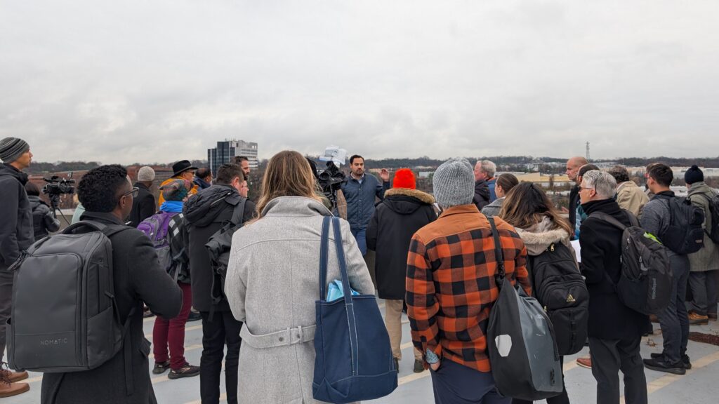
Pictured: Matt Sanchez, Urban Atlantic, speaks to the group, overlooking the site for the new affordable senior building located across Garden City Drive. Photo by Dan Behrend.
Co-sponsors: CSG, WMATA, MDOT & RISE Prince George’s
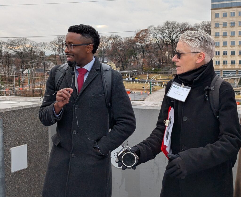
Pictured: Ray Biggs, II, Senior Project Director, Purple Line, Maryland Transit Administration, and Cheryl Cort, CSG. Background: Purple Line station under construction and the IRS building.
CSG’s recommendations to MDOT on investing in more sustainable transportation in Prince George’s County (MD)
November 3, 2025
Hon. Aisha N. Braveboy
County Executive
Hon. Edward P. Burroughs III
Prince George’s County Council Chair
Acting Secretary Samantha J. Biddle
Maryland Department of Transportation
Wayne K. Curry Administration Building
1301 McCormick Drive, Largo MD
RE: Transportation priorities in the Maryland Consolidated Transportation Program (CTP) for Prince George’s County
Dear County Executive Braveboy, County Council Chair Burroughs, and Acting Secretary Biddle:
The Coalition for Smarter Growth (CSG) advocates for walkable, bikeable, inclusive, transit-oriented communities as the most sustainable and equitable way for the Washington, DC region to grow and provide opportunities for all. We also support and work closely with RISE Prince George’s, a group of county residents and allies advocating for policies and practices that build shared, sustainable prosperity in Prince George’s County by creating safe, walkable, inclusive and transit-oriented communities. The following letter reflects the views of the Coalition for Smarter Growth.
Appreciation for County and MDOT work on I-495 Southside, next steps needed
We first wish to acknowledge the recent decision at the Transportation Planning Board (TPB) that sent VDOT’s I-495 Southside Express Lanes proposal back to the drawing board. We want to thank County Executive Braveboy, the Prince George’s County Council and state delegation, and especially Council Member Eric Olson.
The TPB rightly decided to hold off on adding the VDOT project to the region’s long-range transportation plan, Visualize 2050. We agree with Prince George’s officials that VDOT’s proposals did not adequately address Maryland’s concerns
Going forward, we ask the county and MDOT to ensure that a rebooted VDOT NEPA study:
- Revises the project purpose and need statement to remove bias for private express lanes and fairly considers a range of alternatives;
- Develops and evaluates alternatives to highway expansion such as near-term conversion of shoulder lanes to bus/HOV lanes, new expanded travel demand management (TDM) programs, alternative managed lanes concepts (e.g., HOTTER lanes, Flexi-HOT lanes) that are fairer for travelers and don’t require highway widening, and a longer-term Metrorail and transit-oriented development alternative;
- Ensures that VDOT conducts timely and adequate analysis on the impacts of any proposal to expand 495 lane capacity on local arterials like MD 210 and the creation of new traffic bottlenecks; and
- Commits to funding expanded transit services for Maryland residents and workers crossing the Wilson Bridge.
Recommendations for Prince George’s and the Maryland CTP:
- Support continued commitment to WMATA and local transit operations in the FY26-31 Consolidated Transportation Plan (CTP): We commend Maryland for continued funding of WMATA, the Purple Line, and Prince George’s County locally operated transit system (The Bus). We ask you to support WMATA’s Better Bus program, and the implementation of Prince George’s Transit Vision Plan.
- Support continued Complete Streets investments over the next 6 years: We support the state’s investment in Complete Streets and specific Prince George’s state road investments, given the county bears a disproportionate share of fatal traffic crashes in the state. We commend MDOT for the increased allocation to complete streets in the draft FY26-31 CTP. This critical program uses the Pedestrian Safety Action Plan (PSAP) prioritization as its guide, beginning with improvements to MD 650 (New Hampshire Avenue), and MD 410 (East-West Highway), followed with MD 214 (Central Avenue), and MD 201 (Kenilworth Avenue) corridors in Prince George’s. In the future, we ask that MD 458 (Silver Hill Road) be added.
Complete streets should use quick-build safety projects: We urge SHA to start with quick build, low cost interventions that take weeks and months, not years to put in place. It is urgent to put critical safety improvements in place such as reallocating excess road capacity to safety needs for all users, closing of free right turn/slip lanes, lane width reduction, and other measures to reduce hazardous design speeds of roadways and minimize exposure of people walking and riding bicycles to high-speed motor vehicles. Continued effort to use low-cost, quick build interventions are essential for PSAP corridors and the many other state roadways where people face the risks of high-speed traffic.
- Rethink highway capacity expansion projects because we cannot afford to keep investing in ever bigger roads and intersections that chase spread out development while neglecting enhanced transit, walk, bicycle facilities and safer, better connected streets for existing communities. All projects should also advance the state of Maryland’s adopted goal to reduce vehicle miles traveled (VMT) and greenhouse gas (GHG) emissions. We ask that the expense of the proposed highway and arterial capacity expansion projects be reconsidered for less costly alternatives: safety interventions, improved commuter transit service, bus priority and BRT, and travel demand management programs. Below are some of the projects we ask MDOT to reconsider and redesign.
- Reconsider the Medical Center Drive interchange expansion to help Downtown Largo and Central Avenue Corridor connectivity: We urge the county to work with the state to fully reconsider this problematic roadway capacity expansion project which is programmed for $11M for engineering, right of way and utilities over the next six years. The proposed designs for an expanded Medical Center Drive and I-495 Interchange undermine nearby transit-oriented development and would further degrade already poor pedestrian access. There are better solutions to supporting the growth of Downtown Largo and the revitalization of the stadium site.
We ask that the County work with the state to reposition the construction of the Central Avenue Connector Trail and bridge that connects Largo to Morgan Boulevard Metro station as a top priority. We also urge expediting the redesign of the oversized, high speed MD 214 into a complete street. This is also a key part of the solution for greater access and connectivity.
- MD 210, Indian Head Highway grade-separated interchanges from I-95/ I-495 to MD 228 (10 miles). The FY26 CTP budgets ongoing costs for engineering at $9.7 million. Reconsider these MD 210 projects to address safety and operational improvements — without capacity expansion. Consider TDM programs and bus transit priority to address long-distance commuters. We support advancing the recommended shared use path along MD 210.
- Support for MDOT process to improve Chapter 30 project prioritization – CSG is glad to see the pilot process underway by MDOT to provide a clearer process that helps Maryland communities like Prince George’s get good projects implemented while addressing state priorities like safety, sustainability, and giving residents travel options beyond driving.
Again, we appreciate the priority that MDOT has made to transit and complete streets. We urge the county and MDOT to work to revise roadway capacity expansion projects to address safety, create cost-effective multimodal travel environments, and avoid endless cycles of expanded capacity.
Thank you for your consideration.
Cheryl Cort
DC and Prince George’s Policy Director
Bill Pugh
Transportation and Climate Policy Director
What’s in store for Bowie State MARC Station? A site tour on Sept 29, 2025
On September 29, 2025 we discussed the potential of the Bowie State University MARC station area to be a vibrant transit-oriented community.